Log in
All resources
Create a design
947 Free Artworks of Maps Of The Netherlands
joan blaeu
copper engraving print
1667 maps
atlas maior, vol 4 (netherlands) - joan blaeu, 1667 - bl 114.h(star).4
british library
bibliothèque nationale de france
map of maastricht by willem and johannes blaeu (1649)
gemeente atlas van nederland - north brabant
atlas van loon
carte des pays-bas catholiques by guillaume sanson
locator maps of the harbour of rotterdam
zalmhaven (rotterdam)
17th-century maps of the netherlands
maps by pieter van der keere
gemeente atlas van nederland - north brabant
dieden
maps by pieter van der keere
old maps of friesland
maps of the hague by braun & hogenberg
1666 in the hague
gemeente atlas van nederland - north brabant
oerle
old maps of hindeloopen
baroque
maps in the library of congress
1670 maps
maps of heusden, north brabant
atlas van loon
siege of sluis 1604
old maps of sluis
maps by guillaume sanson
old maps of friesland
old maps of axel
atlas van loon
media from regionaal archief alkmaar
oudkarspel
gemeente atlas van nederland - north brabant
maps of werkendam
gemeente atlas van nederland - drenthe
maps of aa en hunze
novi belgii, atlas maior
maps of new england
atlas maior, vol 4 (netherlands) - joan blaeu, 1667 - bl 114.h(star).4
1667 maps
gemeente atlas van nederland - groningen
maps of termunten
map of maastricht by willem and johannes blaeu (1649)
markt (maastricht)
gemeente atlas van nederland - south holland
old maps of gouda
gemeente atlas van nederland - north brabant
meeuwen, netherlands
atlas maior, vol 4 (netherlands) - joan blaeu, 1667 - bl 114.h(star).4
1667 maps
map of maastricht by willem and johannes blaeu (1649)
city gates in maastricht
history of the low countries
netherlands in the 1620s
gemeente atlas van nederland - limburg
maps of tegelen
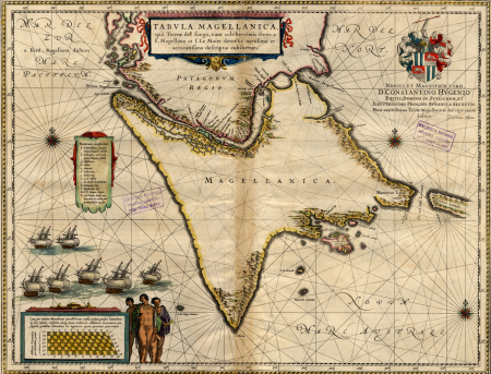
17th-century maps of the strait of magellan
maps by willem and johannes blaeu
1700s maps of the netherlands
maps by nicolas sanson
carte des pays-bas catholiques by guillaume sanson
maps by alexis-hubert jaillot
atlas maior, vol 4 (netherlands) - joan blaeu, 1667 - bl 114.h(star).4
1667 maps
vesting bourtange
atlas van loon
daniel de la feuille
1747 maps
siege of bergen-op-zoom 1622
conflicts in 1622
atlas van der hagen (volume 2)
atlas van der hagen
gemeente atlas van nederland - north holland
egmond-binnen
gemeente atlas van nederland - north brabant
maps of deurne, netherlands
map of maastricht by willem and johannes blaeu (1649)
sint-maartenspoort (maastricht, gate)
old maps of breda, netherlands
adriaen jan bogaerts
cartouches by alexis-hubert jaillot
cartouches by sanson family
gemeente atlas van nederland - north brabant
old maps of breda, netherlands
gemeente atlas van nederland - overijssel
old maps of kampen, netherlands
maps by pieter mortier
old maps of asia
cartouches by willem and johannes blaeu
coats of arms of enkhuizen
sanson maps of the netherlands
alexis-hubert jaillot
17th-century maps of amsterdam
1620s maps of the netherlands
16th-century maps of amsterdam
maps by jacob van deventer
maps by hendrik hondius the younger
old maps of overijssel
venezuela, cum parte australi novae andalusiae - btv1b53196851w
17th-century maps of venezuela
maps of rotterdam by braun & hogenberg
maps of delft by braun & hogenberg
old maps of north holland
zaandam
carte des pays-bas catholiques by guillaume sanson
bibliothèque nationale de france
maps in the rijksmuseum amsterdam
published by frans buffa & zonen
september 2016 in amsterdam
burgerzaal map
maps of the land of valkenburg
guillaume sanson
maps from the earth and its inhabitants, vol. iii
1870s maps of belgium
map of maastricht by willem and johannes blaeu (1649)
joan blaeu
1600s maps of the netherlands
1609 maps of europe
prints and drawings of nijmegen
valkhof, nijmegen
atlas maior, vol 4 (netherlands) - joan blaeu, 1667 - bl 114.h(star).4
1667 maps
hollandse ijssel in gouda
history of gouda
map of maastricht by willem and johannes blaeu (1649)
statenkwartier (maastricht)
construction drawings in the stadsarchief amsterdam
old maps of amsterdam
maps in the british museum
clément-pierre marillier
map of maastricht by willem and johannes blaeu (1649)
history of wyck (maastricht)
1880s maps of the netherlands
1880s maps of belgium
gemeente atlas van nederland - utrecht
jacob kuyper
carte des pays-bas catholiques by guillaume sanson
robert cordier (engraver)
carte des pays-bas catholiques by guillaume sanson
robert cordier (engraver)
maps of krimpenerwaard
atlas novus (blaeu)
maps of the course of the rhine by guillaume sanson
bibliothèque nationale de france
map of ghent by jan blaeu
flandria illustrata
maps of wachtendonk
frans hogenberg
atlas maior, vol 4 (netherlands) - joan blaeu, 1667 - bl 114.h(star).4
1667 maps
atlas maior, vol 4 (netherlands) - joan blaeu, 1667 - bl 114.h(star).4
1667 maps
atlas maior, vol 4 (netherlands) - joan blaeu, 1667 - bl 114.h(star).4
1667 maps
atlas maior, vol 4 (netherlands) - joan blaeu, 1667 - bl 114.h(star).4
1667 maps
atlas maior, vol 4 (netherlands) - joan blaeu, 1667 - bl 114.h(star).4
1667 maps
atlas maior, vol 4 (netherlands) - joan blaeu, 1667 - bl 114.h(star).4
1667 maps
atlas maior, vol 4 (netherlands) - joan blaeu, 1667 - bl 114.h(star).4
1667 maps
atlas maior, vol 4 (netherlands) - joan blaeu, 1667 - bl 114.h(star).4
1667 maps
maps in the rijksmuseum amsterdam
1820s maps of europe
atlas maior, vol 4 (netherlands) - joan blaeu, 1667 - bl 114.h(star).4
1667 maps
atlas maior, vol 4 (netherlands) - joan blaeu, 1667 - bl 114.h(star).4
1667 maps
atlas maior, vol 4 (netherlands) - joan blaeu, 1667 - bl 114.h(star).4
1667 maps
atlas maior, vol 4 (netherlands) - joan blaeu, 1667 - bl 114.h(star).4
1667 maps
atlas maior, vol 4 (netherlands) - joan blaeu, 1667 - bl 114.h(star).4
1667 maps
atlas maior, vol 4 (netherlands) - joan blaeu, 1667 - bl 114.h(star).4
1667 maps
atlas maior, vol 4 (netherlands) - joan blaeu, 1667 - bl 114.h(star).4
1667 maps
atlas maior, vol 4 (netherlands) - joan blaeu, 1667 - bl 114.h(star).4
1667 maps
atlas maior, vol 4 (netherlands) - joan blaeu, 1667 - bl 114.h(star).4
1667 maps
atlas maior, vol 4 (netherlands) - joan blaeu, 1667 - bl 114.h(star).4
1667 maps
atlas maior, vol 4 (netherlands) - joan blaeu, 1667 - bl 114.h(star).4
1667 maps
atlas maior, vol 4 (netherlands) - joan blaeu, 1667 - bl 114.h(star).4
1667 maps
atlas maior, vol 4 (netherlands) - joan blaeu, 1667 - bl 114.h(star).4
1667 maps
atlas maior, vol 4 (netherlands) - joan blaeu, 1667 - bl 114.h(star).4
1667 maps
maps of 's-hertogenbosch by braun & hogenberg
maps of leuven by braun & hogenberg
old maps of north holland
maps by isaak tirion
maps by john cary
1799 maps
gemeente atlas van nederland - zeeland
bommenede
map of maastricht by willem and johannes blaeu (1649)
first medieval city wall of maastricht
maps from university of amsterdam special collections
atlas der neederlanden
501 - 600 of 947
Next page
/ 10


![Manatvs located on the Noot [sic] Riuier., 1639](https://cdn.creazilla.com/illustrations/10001304673/manatvs-located-on-the-noot-sic-riuier-1639-md.jpg)


![[Map of the castellania of Gent], Joan Blaeu, 1667](https://cdn.creazilla.com/illustrations/10000630608/map-of-the-castellania-of-gent-joan-blaeu-1667-md.jpg)